 |
Visitors Center
|
The last time I was in this area was in the late 80's, late at night after work. My friends and I drove out to the Elfin Forest/Harmony Grove/Questhaven area because we heard rumors about mysterious religious cults, drug houses and hell holes. When we stopped in front of the drug house and got out of the car, within a few seconds all the outside flood lights came on and we jumped in my car and drove out, along the narrow, windy road, very fast. That was a fun night. Well, there are still strange religious retreats out there that are hidden behind gates, fences and hills, but now there is the Elfin Forest Recreational Reserve which is popular with hikers and mountain bikers.
 |
| Owl with Sunglasses |
At the main parking lot there is a very nice visitors center. Almost as nice as one you might see at a national monument or state park. We didn't spend very much time inside, but long enough to takes some photos of stuffed wildlife wearing sun glasses.
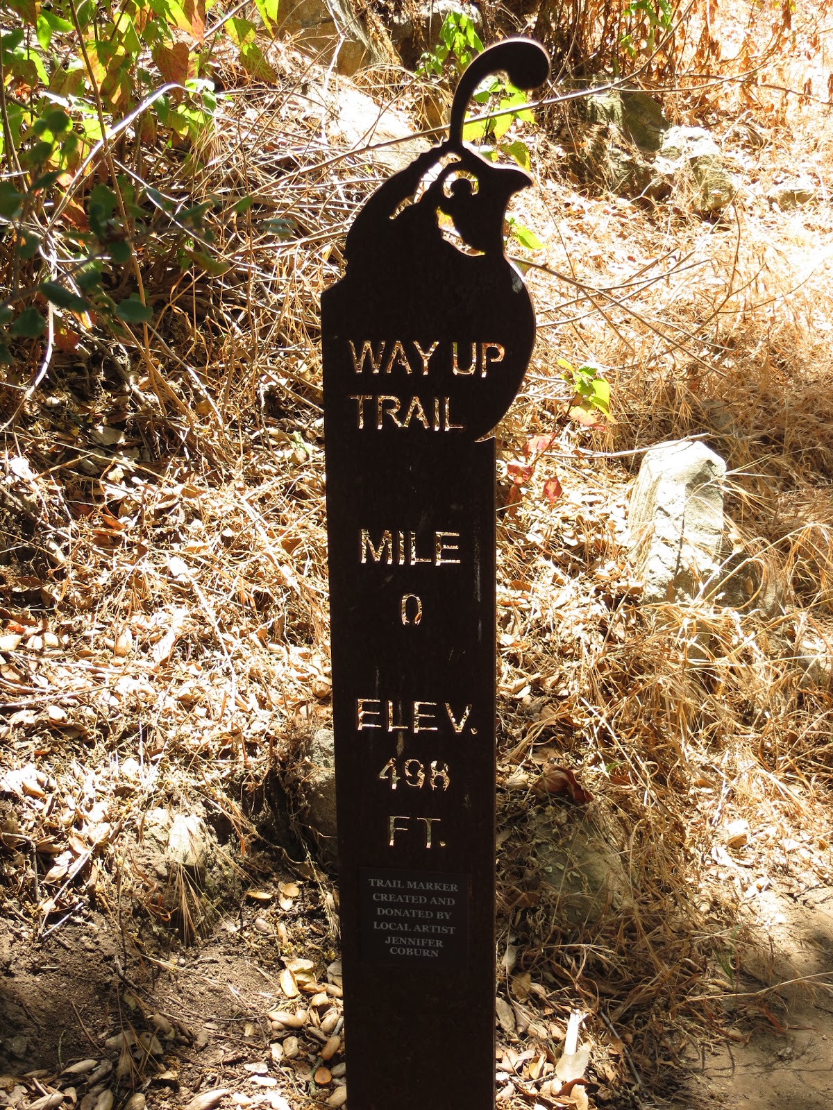
The map at the trail head shows all the trails and distances. We decided to follow that main trail, called the Way Up Trail. For some reason I had the idea that all the trails were flat, but I was way wrong. This trail climbs steeply up the hillside and before you know it you are looking way down at the parking lot. It wasn't hot so we didn't need too many breaks, and luckily I was well stocked with water.
 |
| Small creek |
Once you go over the small creek the vegetation along the trail is your typical dry chaparral, with no trees for shade. There are many trail markers along the way to let you know what trail you are on, the distance you've traveled, and what facilities are located at the trails end, such as benches and restrooms. We had no specific goal other than to view the reservoir which I had never seen.
 |
| One of many trail makers |
The trail wasn't that crowded, and we talked to other hikers and bikers along the way asking them about the trails and what to see. So we just kept heading up and then towards the direction that we thought the lake was until we finally saw the reservoir. It isn't all that big, or at least it didn't look big, but the water was very blue and clean. I think I read an article about how they were going to pump water in from Lake Hodges but decided not to because that water was much dirtier and would have ruined this lake, which seems to have no recreational use. It is just for drinking.
 |
| Me with Lake |
We continued exploring, and found even better views of the lake like the one below that was at a summit along a trail that led to a Lake Hodges lookout. We didn't take that trail because it was too long and I've seen Lake Hodges many times. In the background you can see Mt. Woodson and Iron Mountain. You can also see how low the water level is.
 |
| Olivenhain Reservoir |
On the way back down, we took the botanical garden trail, expecting to see a garden. Instead it was just another trail but with posts with numbers on it that probably referred to some guild that told you about the plants in that area. Near the bottom there were trees with shade, and then we had to walk across some rocks to get over the creek where kids were swimming in the slimy, green water as the parents watched.
I wished I had recorded the trip on my GPS so I'd know how far we walked. We were hiking for less than two hours but it was a pretty good workout. On the way home I took a different way out that took us though the new community of San Elijo Hills. I knew this places existed, but I had no idea how big it was. All the buildings, houses and even the school looked like they were just build. It was well landscaped and probably an expensive place to live. Once we got back to freeway we stopped at Rubio's before heading back home.


1 comment:
It's weird how you can live here all your life and just now are going here. I've never been there either.
Post a Comment