
I've wanted to hike Cuyamaca Peak, which is located in Cuyamaca Rancho State Park and the Cleveland National Forest, for many years. My friends and I are training for a hike up San Gorgonio on July 1st, and I thought Cuyamaca Peak would be a great training hike as well as an enjoyable day hike. Out of the five people who are planning to hike Gorgonio, only my friend Dan and I made this hike.
Looking at various maps and web sites, I saw that the easiest route up the mountain was the Lookout Fire Road from Paso Picacho campground. The round tip is about six miles (every site lists different distances, from 2.5 to 3.5 miles one way) but I wanted to extend the hike a little longer. So I found a route from LocalHikes which sounded interesting.

We arrived at the Paso Picahco campground around 9 AM and began hike by 9:15. We purchased a map of the park when we paid our $8 day use permit. Looking at this map, and comparing it to the one I had printed the day before, I noticed that the trail names from one map weren't on the other. So we decided just to start hiking on what seemed like the correct trail. The goal was to take Azalea Glen Trail to the Conejos Trail, which then connected to the Lookout Fire Road. The beginning of the hike was on a narrow trail with very tall vegetation on both sides. This made for a nice, cool hike, but when we caught up to a large group of slow hikers (mostly children), it took a little maneuvering to pass them.
Still not knowing the exact route to take, each time we came to a trail junction I'd take out the map to see where we were. Many of the trails we saw weren't on the map, so when in doubt we just kept on the same trail. I was pretty sure that the rail would intersect with Azalea Springs Fire Road. Along the way we talked to another group and they also weren't sure if they were on the right trail. They were just doing the "loop", but the hike was taking longer than they thought and their kids were getting tired. We both looked at the map, and using my cool new Casio Pathfinder watch, which has an altimeter, I saw we were at about 5100 feet elevation, so following the contour lines on the map I estimated our location, determined we were on the correct path, and continued to hike on.

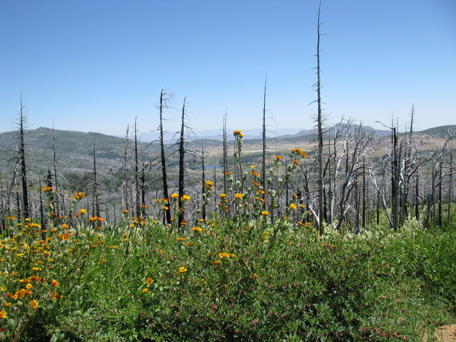
At the beginning of the trail there was evidence that the trail had been recently closed, and we saw many trees that had fallen down across the trial had been recently cut, plus we could hear chain saws in the distance. The entire Cuyamaca park was almost completely devastated by the Cedar fire in 2003. You could see that almost all the tall trees were burnt, and all the new growth was smaller trees and bushes.
After hiking for about an hour, we made it to the fire road. From here, the trail was marked with signs and white chalk indicating which direction to go. The trail was closed to the north, but we knew we wanted to keep going southwest. Then we came across another trail junction. Looking at my map, it looked as if we should have kept going straight, but that trail looked closed, so we followed the white chalk arrows again, which led to a very muddy tail. Wearing good hiking boots prevented my feet from getting wet, but there was girl with the other group wearing sandals, and she wasn't very happy to be hiking through the mud.
Eventually we made it to the Lookout Fire Road. However, we never saw the Conejos trail I wanted to take. Unfortunately, the fire road was just that, a paved road. Not much fun for hiking, as the pavement is harder than dirt, and not very scenic. As we continued to hike, I saw a peak nearby, and wondered if that was Cuyamaca Peak. So I took out my cell phone and launched an application called BackCountry Navigator. I had installed the application the day before and downloaded a topographical map of the area onto my phone. The program allows you to use your phone's GPS to track your route using the maps offline (without a cell signal). Since I had never used this app before, I wasn't sure how to determine direction, so I didn't know where that peak was in relation to our position. I was a little concerned we were on the wrong path, especially since we couldn't see any other peak. I quickly gave up, turned off the phone, put the map away and proceeded up the road. (I located that peak on-line when I got home and found it was Stonewall Peak, which is actually on the east side of highway 79.)

When we finally saw other people hiking down the road, we figured we were going the right way. Then we could see the peak, or at least some towers and antennas. The road was quite steep, as it was designed for vehicles and not people. As we got higher the views got better, but I knew the best views would be from the top, where you could see 360 degrees and 100 miles on a clear day, and today was very clear, as least in the mountains. It was in the mid 70s, with a slight breeze. Perfect hiking weather.
The peak that at first looked really far away quickly got closer, and before we knew it, we were at the top! Well, actually I went ahead of Dan and reached what I thought was the peak, but after about five minutes of waiting for Dan, I realized that the trail just before the peak must have been the correct trail to take, and sure enough it was. So Dan reached the summit before me, not that we were in any kind of race.

There were only a few other people on the summit, including a couple that passed us along the way, and we overheard the woman saying something like "She's going through a divorce, so she probably has a gun.". Hmm - let's avoid them. Except they were the only ones at the top available to take a group photo of Dan and I, and there were both very nice.
From the summit, the views were amazing. Looking west, you couldn't quite see the Pacific Ocean because it was covered in June Gloom. Off to the North you could see many mountains, some covered with snow. Using a web site when I got home, it showed that San Jacinto and San Gorgonio were visible. Kind of cool that we could see the mountain we were going to be hiking the three weeks from so far away. Off to the east the mountains of the Anza-Borrego desert were visible, and finally looking south towards Mexico, there was lots of haze in the air, limiting the view making it the least picturesque direction.
After taking my fill of photos, and the standard 30 second, narrated movie, we headed down. When I hike, I'm usually oblivious to my surroundings. I tend to concentrate on the hike, taking time to look up and notice the scenery in the distance and not noticing what's just along the trial. My friend Dan tends to notice everything, such as flowers, plant, bugs and rattle snakes. Yes, if he hadn't said anything I might have stepped on the rattle snake laying in the middle of the road. It was about 10 feet away and just laying there, not coiled up. But as we stepped closer, he began to slither away, shaking his rattle to warn us, but quickly disappearing in to the brush. The snake was the biggest wildlife we saw. No dear, mountain lions (which is good) and not even a rabbit.
Once the snake was gone we continued hiking down. Up to this point I hadn't experience much pain in my muscles, knees or feet. But I could feel one toe starting to burn, like I was getting a blister. So we stopped so I could put on a blister pad. It made a big difference and my foot felt better, but just a few minutes later we came around a corner and there was the camp ground. I had to laugh at myself. If I had waited just two minutes I would not have needed to stop to put on the pad. The hike down was much quicker and neither of us knew how close to the camp we were.Also, we were hiking so fast we never even saw the trail we took to get to the fire road. Oh yeah, on the way up I finally did see the Conejos trail, but who knows what path we should have taken to get there. I read online that the trail was actually a "hodge-podge" of trails, which kind of makes since.

Back at the car, I looked at my watch and it was 2 PM. So we hiked for about 5 hours. I still not sure how far, but I estimated it was less than 8 miles. Still, a very good training hike. I must say, it felt good to take off my boots and put on comfortable shoes.
My plan for the day was to eat lunch on the way home and then once home, take an afternoon nap. However, since the hike took longer than expected, lunch at 3:00 became "lunner", and the nap became bed time. It was a good day, and when I woke up this morning, I still felt good and better yet my knees don't hurt and my leg muscles aren't too sore or tight. Maybe it will catch up to me tomorrow at work. Work - yuck!
