 I create some overlays using Google Earth (I love that program), that shows the path I took today on my hike up Iron Mountain in Poway. The path I took up Iron Mountain today was shorter than one I took last year but longer than the usual trip up. From the trail head, follow the red line to the purple line. The purple line is a short-cut that merges with the Ellie Lane trail (in red), which connects to the IM main trail and the junction. Then I took the blue line to the top and back to the trail head. Be warned, the short-cut was very steep and narrow in places. I was worried about rattle snakes, since May is peak rattle snake season they say.
 The short-cut was nice because I encountered only three other hikes on the trail. The main path had 100's of hikers. It was also more scenic, with ponds, ducks and small groves of trees.
 Small grove of tress. Taking this path also added more elevation gain. Because you have to hike over a ridge at 2400 feet and then down to the junction at 2000 feet, the total elevation gain is about 1500 feet instead of 1000 feet. The end result is a big blister on my left big toe. And more calories burned.
 Ducks. The path I took added 1.5 miles to the hike, making the hike about 7.5 miles. It took about 2 1/2 hours total.
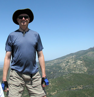
 Me at the top of Iron Mountain. Only a few other people at the top by the time I summited. Most of the families with kids must have started hiking earlier and were off the mountain by 3 PM.

Clear but hazy day. Good view of San Diego none-the-less. Plus, the air was cool and refreshing.


