I had been wanting to hike San Gorgonio for many years. I knew it was going to be a difficult hike, but it was still more of a challenge than I had expected. We, meaning my friend's and I, did this hike as a warm-up hike for our one day hike up Mt. Whitney next month on July 2nd.
We drove up in the morning, wanting to get an early start, but due to longer that expected stops along the way and a wrong turn on highway 38 we didn't starting hiking until 9 AM. Also, we were lucky to get a permit. There was only one left at the ranger station. We did not request a permit in advance because we had just decided on a date last week.
Of the six people on this hike, all but Kevin had been going on local San Diego hikes to get ready for Whitney. Kevin was a last-minute addition for what he was told would be a "small hike".

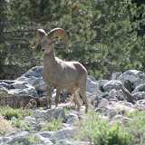
The beginning of the trail is under construction, so there is a detour through the river bed. Yellow flags mark the path. This trail consisted of soft sand and lots of rocks. Along the way, however, we encountered a bighorn sheep! I had never seen one in the wild before, and he/she stood there long enough for me to take several photos before it ran up the steep hillside. This was the highlight of the hike, and we had just begun!
Eventually we reached the regular trail and crossed the creek. From there the trail heads straight up the side of the valley. There are switchbacks, but they are still very steep. We knew in advance about this part of the hike, so we just took it slow. Along the way we were passed by a couple and two dogs. The women told us the trail got easier soon. However, we encountered her later and she gave us time estimates that were way off. More on that latter.

Sure enough, the trail got easier, but already the six of us had broken up into three groups. I was with the "fast" group, which may have been a mistake, because my legs gave out before reaching the summit. Yes, none of us summited.
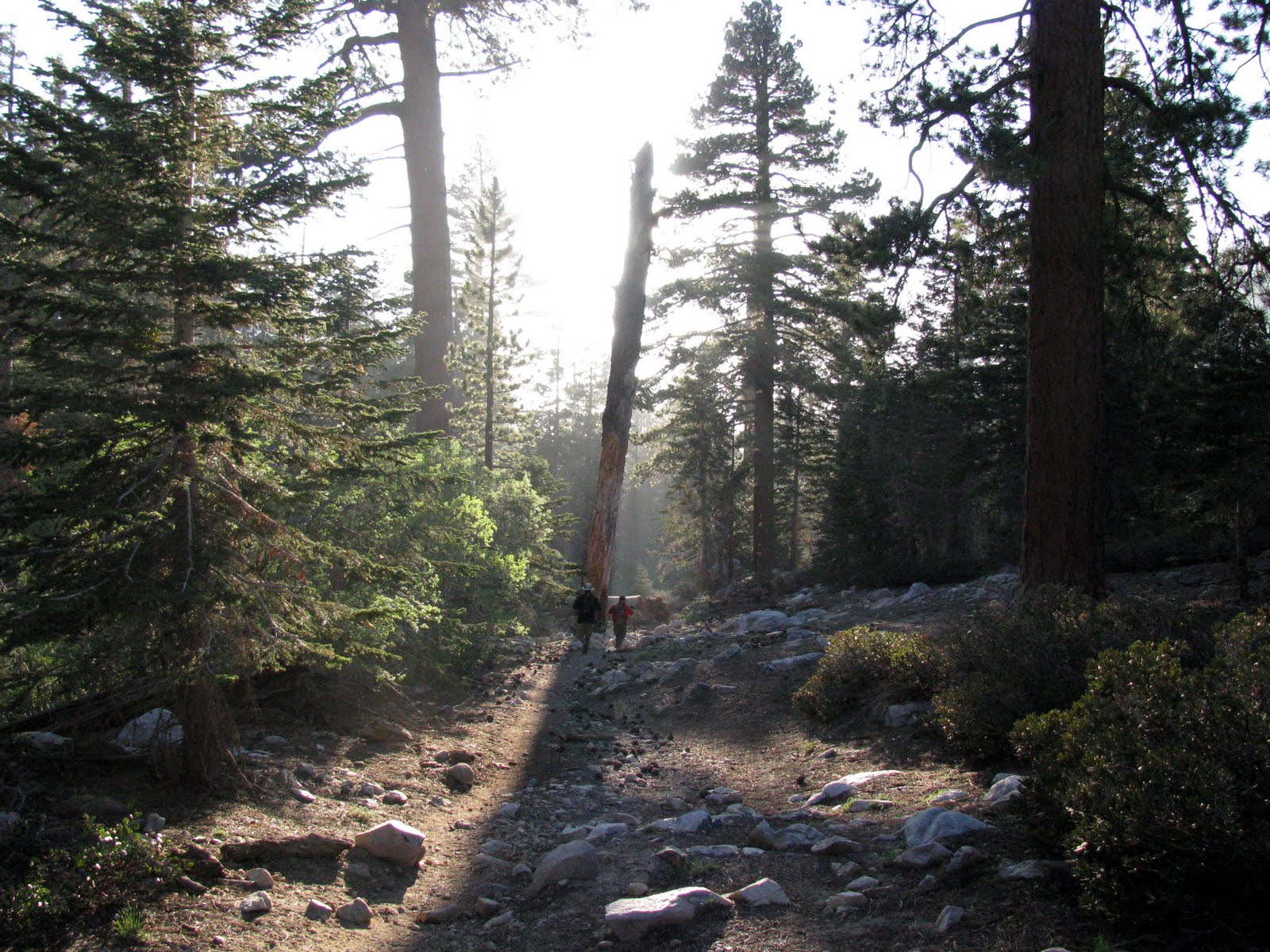
The trail follows Vivian Creek. The trail was very scenic and luckily not too warm, with a nice cool breeze. I was wearing long hiking pants instead of my shorts, which was good to keep off the many mosquitoes. Every time we stopped, the bugs attached us. I got about 5 bites on my arm. We stopped several times to rest and eat. There weren't many other hikers on the trail. One large group of hikers with full packs and warrior-like face paint came hiking down the trial. They looked more prepared than us and were friendly, despite the face paint.
As we walked along the trail, we encountered many fallen trees which we had to either climb over, under or around. One mistake we made was not having a good map. I had a topographical map that I printed out at home, and when we looked at the map to see where we were, we could not read it. There was a junction at Halfway Camp and we were not sure where to go. Luckily another friendly couple told us to keep going up, following the High Creek trail. They were headed to Halfway Camp to camp for the night. Jim had a good map, but he was way back behind us.

I was still hiking with Steve and Kevin, and we knew Darin and Lee were not too far behind. But Lee was hiking with Jim, who was struggling with the hike and going very slow. So we kept going. Eventually we reached another creek, which turned out to be High Creek. We realized at this point that we were not as far along the trail as we thought, no thanks to my poor map. We should have filled up with water here, since I had my water filter, but we didn't. Later I ran low on water and had to conserve. I was drinking way less than three years ago when I drank one liter per hour of hiking, and was dehydrated and just didn't know it.

Shortly after crossing the stream, we met up with the couple from earlier who were headed back down. The woman told us that they did not summit because her husband, who did not talk at all for some reason, had a medical condition preventing him from going higher that 10,000 feet (and talking?). She told is it was 15 minutes to the next crest, and 45 minutes from there to the summit. She was way off. It took us 50 minutes to get to the crest and had we summited, it would have taken another two hours!

Once we got to the crest, we stopped to eat. After a few minutes we sighted Lee and Darin hiking up. Once they caught up we continued on, sharing stories of what we had seen so far. At this point, Jim was still hiking up, even though he had been told to go back to the car. But he did not and eventually he did make it to the 10,500 foot level.
As we kept hiking, once again Steve, Kevin and I took the lead. By this point my legs were getting very tired. I wasn't sure how much farther I could get. Also, our pace was slowing, except for Kevin, who, for wearing just running shoes and not being prepared, was doing very well. We crossed a long snow field and stopped shortly after to rest. The altitude was getting to us. As we rested, we saw Darin coming up the trail. When he joined us we continued up, looking at the trail high above on the mountain. A man we talked to a few times earlier told us the route up, but we could not picture it in our minds. He has hiked this trail every year as a warm up for hiking Mt. Shasta. This man must have been in his 60s and was carrying a full backpack. He said he was going to summit and was prepared to hike in the dark.

We kept debating when to turn around. I had expected it to take almost six hours to summit, and it was now 3 PM, six hours into the hike. We decided to hike until 4PM. The four of us got up the trail to a point where Steve and Kevin stopped. Darin and I kept going, but when I realized it took us five minutes to hike about 500 feet, I was done. My body was done. My muscles were done. Darin was not. He kept going up and round the corner, hoping to reach the crest of the mountain. I just sat there for about five minutes before walking back down to the others, and then we hike down back across the snow field and waited for Darin. It was already passed 4PM. Eventually we saw him hiking down, and he talked to the old man who told him he was only about a 1/2 mile from the summit, which turned out to be true. But Darin said every time he thought he was near the Divide Trail junction, there was just one more turn.

We were all disappointed, but knew that we still had a long hike back down. It was funny, after hiking down for five minutes we looked up at where we just were and were amazed at how fast we got down as compared to how long it took us to get up to that point. Another 10 minutes of hiking and we were happy to see Lee and Jim waiting for us. Yes, Jim made it pretty far. Slow but steady. We took time to eat more food and prepare for the long journey back. At this point two of us were out of water and some low on food, but other's had extra food and water to share. That's what hiking is all about. Having fun and watching out for your fellow hikers.
So the decent began. Like I said, we made great time hiking down. Even though we were tired, sore and getting headaches, we made it to High Creek in less than an hours. We all stopped to filter water with our two filter pumps. Nothing tastes better than fresh filtered cold mountain water. I filled a one liter bottle with water and added two Nuun tablets and drank half the bottle right there. Then I added another liter of water to my Camelback bladder. Once we all had a refill of water, the hike continued.

Time went by quickly, and we more or less stayed together as a group, with good old Jim leading the way. His mission was to get back before dark. I had to remember to stop and take some photos on the way down, and not just hike without enjoying the scenery. We made it to the top of the steep section at the beginning and just kept going. In reviews of this hike people said you don't realize how steep this part of the trail is until you hike back down. That is somewhat true, but I knew coming up how steep it was. By this time my knees were starting to hurt. Not as bad as I expected, but I didn't let the pain slow me down as I have in the past. I used my hiking poles to cushion my steps on the steep trail, and today I can feel in my arms and back just how much I used my poles.
Even though it was getting very dark along the trail, I could see down in the valley though the trees that the sun had not yet set. I was also amazed how far down the Vivian Creek bed was but knew that with the steep trail we would be there soon. The trail was so steep I had to be very careful not to slip or twist my ankle. Finally, we made it, just as the sun was setting. All six of us got to the river and continued on. Even though we had headlamps, Jim suggested we not use them since our eyes were adjusted to the dark and with the lights we would lose our night vision.

We crossed back across the river and then once again followed the yellow ribbons that marked the detoured path. But as it got darker, and everything turned to black, white and gray, it was difficult to spot the yellow flags. But we kept going, hiking along the soft sand.
We reached the parking lot just as all sunlight was gone. We had two cars and proceeded to take our boots off and put on more comfortable shoes. Everyone was exhausted. Kevin asked, "So what part of this trip did you guys find fun?". I told him that in ten years we would look back upon this adventure and remember only the good times. I know Kevin had some fun, as at one point near the top he got ahead of us and threw snowballs at Steve and I as we crossed the snow field.

We were all ready for dinner. However, since we were not familiar with this part of town, it took us a while to find a place to eat. We ended up and an In-N-Out that was very busy for being 9PM on a Thursday. I had not eaten at In-N-Out in probably over eight years, but a double-double never tasted to good. After eating we all felt much, much better. But Steve, who drove us from San Diego, turned the keys over to Jim to drive us home. We said good by to Darin who does not live in SD.

The drive back seemed to take forever. I was sitting up front in the passenger's seat, and my job was to keep Jim awake. Jim did just fine, except he said without his glasses he could not read the road signs. Hmmm. So I had to tell him what lane to be in. We made it safely back to Steve's house, where we unloaded our hiking stuff and all headed home.
I got home around 11:30, showered, got on the Internet long enough to post an update to Facebook, and went to bed at midnight, after having woken up at 4:15 AM! I was tired, but still had trouble sleeping. I woke up at 8:30, had coffee, breakfast, lunch, long nap and then wrote this blog post.

Everybody said that they never wanted to do this hike again. I do. I have never not summited before unless it was due to weather (snow/rain/lightening). Now that I know what to expect, I think I'd make the summit. Start earlier, hike slower and drink more water.
Next hike - Mt. Whitney!